
-
Research Article
-
Theoretical Foundations of the GeoCapabilities Project and Its Implications for Geography Education
GeoCapabilities 프로젝트의 이론적 토대와 지리교육적 함의
-
Minsung Kim
김민성
- This study aims to introduce the theoretical foundations of the GeoCapabilities approach and to examine how these ideas can be materialized in …
이 연구의 목적은 지오캐퍼빌리티 접근의 이론적 기반을 소개하고, 이를 교육 현장에 적용한 유럽의 GeoCapabilities 프로젝트를 통해 관련 논의가 어떻게 실체화될 수 있는지 …
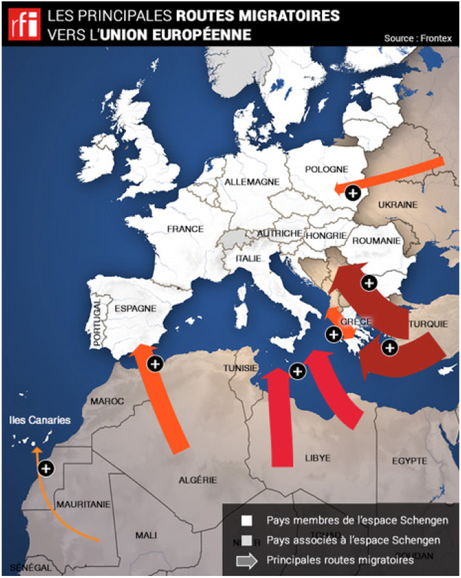
- This study aims to introduce the theoretical foundations of the GeoCapabilities approach and to examine how these ideas can be materialized in educational practice through the European GeoCapabilities project. It further discusses the implications of the GeoCapabilities approach for the future direction of Korea’s geography curriculum and teacher education. GeoCapabilities is defined as the capability to pursue happiness and well-being by living a life that one values, enabled by geographical thinking. Education for fostering GeoCapabilities is grounded in a powerful disciplinary geography curriculum and can be realized through teachers’ active curriculum-making aimed at enacting the Future 3 scenario. In Europe, the geography education community implemented the GeoCapabilities project with “migration” as its central theme. The project proceeded through the stages of thinking geographically, planning lessons, enacting lessons, and evaluating and reflecting on lessons, and it developed a set of pedagogical tools to support each stage. By presenting the GeoCapabilities project, this paper explores how such scholarly and practical movements may inform and advance geography education in Korea.
- COLLAPSE
이 연구의 목적은 지오캐퍼빌리티 접근의 이론적 기반을 소개하고, 이를 교육 현장에 적용한 유럽의 GeoCapabilities 프로젝트를 통해 관련 논의가 어떻게 실체화될 수 있는지 살펴보는 것이다. 나아가 지오캐퍼빌리티 접근이 우리나라 지리교육과정과 교사 교육에 줄 수 있는 시사점을 논의하는 것이다. 지오캐퍼빌리티는 지리적 사고를 통해 자신이 가치 있다고 여기는 삶을 살아가며, 행복과 웰빙을 추구할 수 있도록 하는 역량이다. 지오캐퍼빌리티를 함양하기 위한 교육은 힘있는 지리학 지식 교육과정을 기반으로 하며, 이는 Future 3 시나리오를 실현하기 위한 교사의 능동적 교육과정 만들기를 바탕으로 구현될 수 있다. 유럽의 지리교육계는 지오캐퍼빌리티 함양을 위해 ‘이주’를 주제로 하여 GeoCapabilities 프로젝트를 수행하였다. 해당 프로젝트는 지리적으로 사고하기, 수업 계획하기, 수업 실행하기, 수업 평가 및 성찰하기의 절차로 진행되었고, 각 단계에서 활용할 수 있는 교수학적 도구들을 개발하였다. 본 논문에서는 GeoCapabilities 프로젝트를 소개하고, 이러한 학문적·실천적 움직임이 우리나라 지리교육에 줄 수 있는 함의를 논한다.
-
Theoretical Foundations of the GeoCapabilities Project and Its Implications for Geography Education
-
Research Article
-
The Effects of Public-Interest Geographic Information-Based Service-Learning on Fostering Social Empathy: A Case Study of a Welfare Map Service Project for Older Adults
공익적 지리정보 기반 봉사 학습이 사회적 공감 함양에 미치는 영향: 노인 복지맵 봉사 프로젝트를 사례로
-
Minsuk Son
손민석
- The purpose of this study was to investigate the effects of a geography service-learning project based on the production and use of …
본 연구의 목적은 공익적 지리정보(노인 복지맵) 제작·활용에 기반한 지리교육적 봉사 학습 프로젝트를 설계·운영하고, 해당 프로젝트가 학생들의 사회적 공감 함양에 미치는 영향을 분석하는 …
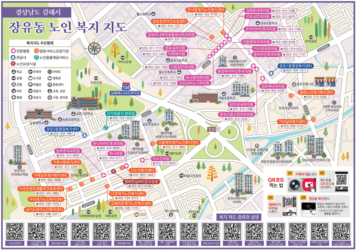
- The purpose of this study was to investigate the effects of a geography service-learning project based on the production and use of public-interest geographic information (a welfare map for older adults) on students’ social empathy. The project was designed as a civic-oriented learning activity in which students examined older adults’ lives at the intersection of individual circumstances and broader social and structural conditions while collaboratively producing and sharing a welfare map for older adults. The study adopted a mixed-methods design combining pre- and post-tests with qualitative data analysis. The results indicated that the experimental group showed a statistically significant increase in social empathy compared with the control group. The increase was greater in the social domain than in the personal domain, suggesting that students came to interpret the difficulties experienced by older adults not only as individual problems but also as issues related to structural conditions such as limited accessibility to welfare information and weaknesses in welfare information delivery systems. Furthermore, the experience of producing and disseminating public-interest geographic information encouraged students to extend their empathy toward civic responsibility and action. These findings suggest that service-learning grounded in public-interest geographic information can provide a meaningful pedagogical approach for fostering social empathy within geography education.
- COLLAPSE
본 연구의 목적은 공익적 지리정보(노인 복지맵) 제작·활용에 기반한 지리교육적 봉사 학습 프로젝트를 설계·운영하고, 해당 프로젝트가 학생들의 사회적 공감 함양에 미치는 영향을 분석하는 것이다. 봉사 프로젝트는 노인의 삶을 개인 차원과 사회 구조적 차원의 교차점에서 이해·해석하고, 연구자와 학생들이 협업적으로 노인 복지맵을 생산·공유하는 시민적 실천을 중심으로 구성하였다. 연구는 학생들을 대상으로 사전·사후검사와 질적 자료 분석을 결합한 혼합 연구 방법으로 수행하였다. 분석 결과, 실험집단은 통제집단보다 사회적 공감 점수가 유의하게 향상되었고, 특히 사회적 영역이 개인적 영역보다 더 높은 점수 향상을 보였다. 이는 학생들이 노인의 어려움을 복지 정보 접근성과 전달 체계의 한계 등 사회 구조적 차원에서 비판적으로 분석하고, 공익적 지리정보를 생산·공유하는 실천을 통해 시민적 책임 의식과 행동으로 공감을 확장하였음을 시사한다. 본 연구는 공익적 지리정보 기반 봉사 학습이 사회적 공감 교육의 지리교육적 실천 가능성을 확장할 수 있음을 제시하였다는 점에서 의의가 있다.
-
The Effects of Public-Interest Geographic Information-Based Service-Learning on Fostering Social Empathy: A Case Study of a Welfare Map Service Project for Older Adults
-
Research Article
-
A Critique of ‘Kitschified’ Field Trips from the Perspective of Elementary Geography Education: Focusing on Merleau-Ponty’s Philosophy of the Body
‘키치(Kitsch)화’된 현장체험학습에 대한 초등 지리 교육적 비판: 메를로-퐁티의 몸 철학을 중심으로
-
In Hwang
황 인
- This study critically examines the ‘kitschification of place’ in current elementary geography fieldwork and seeks phenomenological alternatives to restore geographical reality through …
본 연구는 현행 초등 지리 현장체험학습이 안고 있는 ‘장소의 키치(Kitsch)화’ 현상을 비판적으로 고찰하고, 메를로-퐁티(Merleau-Ponty)의 현상학적 몸 철학을 통해 지리적 실재성 회복을 위한 …
- This study critically examines the ‘kitschification of place’ in current elementary geography fieldwork and seeks phenomenological alternatives to restore geographical reality through Maurice Merleau-Ponty’s philosophy of the body. Today’s fieldwork, characterized by the contemplative gaze of sightseeing through bus windows and worksheet-centered activities focused on fragmented information, reduces students to disembodied consciousnesses and causes perceptual kitschification. To overcome these limitations, this study reinterprets space as a field of existential communion by applying Merleau-Ponty’s concepts of the ‘body-subject,’ ‘lived space,’ and the ‘flesh of the world’ (la chair du monde). Consequently, this paper argues that authentic fieldwork must transcend mere visual observation. It should instead be reconceptualized as an active process of ‘anchoring’ (ancrage), where the student’s body directly intertwines with the unfamiliar history of the place and the lives of anonymous others.
- COLLAPSE
본 연구는 현행 초등 지리 현장체험학습이 안고 있는 ‘장소의 키치(Kitsch)화’ 현상을 비판적으로 고찰하고, 메를로-퐁티(Merleau-Ponty)의 현상학적 몸 철학을 통해 지리적 실재성 회복을 위한 대안을 모색한다. 오늘날 버스 차창 너머로 장소를 구경하는 관조적 시선이나 파편적 정보 수집에 매몰된 활동지 중심의 체험학습은 학생을 탈육화된 의식으로 전락시키고 지각적 키치화를 초래한다. 이를 극복하고자 본 연구는 퐁티의 ‘신체-주체’, ‘체험된 공간’, ‘세계의 살(Chair)’ 개념을 적용해 공간을 실존적 교감의 장으로 재해석한다. 결론적으로 진정한 체험학습은 단순한 시각적 구경을 넘어, 학생의 신체가 낯선 장소의 역사와 익명적 타인들의 삶 속에 능동적으로 닻을 내리는 ‘정박(Ancrage)’의 과정이 되어야 함을 제언한다.
-
A Critique of ‘Kitschified’ Field Trips from the Perspective of Elementary Geography Education: Focusing on Merleau-Ponty’s Philosophy of the Body
-
Research Article

-
A Semantic Network Analysis of Social Perceptions of Climate Anxiety
언어네트워크 분석을 통한 기후불안에 대한 사회적 인식 연구
-
Byungyeon Kim · Jinyoung Kang
김병연 · 강진영
- This study conducted a semantic network analysis of big data from news articles to examine the social perception surrounding climate anxiety. A …
이 연구는 기후불안에 대한 사회적 인식을 확인하기 위해 언론 기사를 활용한 언어네트워크 분석을 실시하였다. 기후불안을 다루고 있는 335편의 언론 기사를 대상으로 네트워크 …
- This study conducted a semantic network analysis of big data from news articles to examine the social perception surrounding climate anxiety. A total of 335 news articles addressing climate anxiety were analyzed using network centrality measures and CONCOR clustering. The results are as follows. First, a dominant perspective was one that framed climate anxiety as an issue confined to specific populations, particularly adolescents and young adults, and reduced it to an individual-level problem. Second, a perception that medicalizes climate anxiety as a negative emotional state is prevalent. This framing positions climate anxiety as a mental health problem, yet pays insufficient attention to its potential positive or adaptive functions, such as motivating climate action or fostering constructive emotional engagement with the climate crisis. Third, public perception tends to emphasize individualized coping strategies, a pattern that reveals the absence of structural or institutional alternatives. Overall, climate anxiety tended to be framed not as a structural problem, but as an issue limited to certain populations or as a pathological condition to be managed and resolved at the individual level. These findings highlight the limitations of current social perceptions of climate anxiety and underscore the need for mental health, educational, and policy responses in the climate crisis era to move beyond individualized approaches toward more structural and collective frameworks.
- COLLAPSE
이 연구는 기후불안에 대한 사회적 인식을 확인하기 위해 언론 기사를 활용한 언어네트워크 분석을 실시하였다. 기후불안을 다루고 있는 335편의 언론 기사를 대상으로 네트워크 중심성 분석과 콘커 분석을 수행한 결과는 다음과 같다. 첫째, 기후불안을 개인 및 청소년·청년층과 같은 ‘특정 집단’의 문제로 환원하는 관점이 두드러졌으며, 이 과정에서 기후위기 영향에 노출된 다양한 집단이 배제될 가능성을 가진다. 둘째, 기후불안을 부정적 정서로 ‘의학화(medicalization)’하는 인식이 형성된 것으로 드러났다. 이는 기후불안을 정신건강 문제로 규정하되, 긍정적 감정·적응적 기능·기후행동 촉진 가능성 등은 충분히 조명하지 않는 한계를 보여준다. 셋째, 기후불안에 대한 ‘개인화된 대응’ 전략에 집중하는 인식이 형성되어 있었으며, 이는 구조적·제도적 대안의 부재를 드러내고 있다. 종합하면, 기후불안에 대한 사회적 인식은 기후불안을 둘러싼 구조적 문제를 드러내기보다 분절된 문제의 영역으로 이해되는 경향성을 보여준다. 이 연구는 기후불안에 대한 사회적 인식의 한계를 드러내며, 향후 기후위기 시대의 정신건강·교육·정책적 대응이 개인적 접근을 넘어 구조적·집단적 관점으로 확장될 필요성을 제기한다.
-
A Semantic Network Analysis of Social Perceptions of Climate Anxiety
-
Research Article
-
The Application of Theory of Didactical Transposition into Geography Instruction: Focusing on Theory of Didactic Situation
교수학적 변환론의 지리 교수에의 적용: 교수학적 상황론을 중심으로
-
Tae-Yeol Seo
서태열
- Didactics in France has developed through Gérard Vergnaud’s Theory of conceptual fields, Guy Brousseau’s Theory of didactic situation, Yves Chevallard’s Theory of …
프랑스에서 교수학은 교수학적 변환과정에 중점을 두고, Gérard Vergnaud의 개념장 이론, Guy Brousseau가 제시한 교수학적 상황론(Theory of didactic situation), Yves Chevallard가 제시한 교수학적 …
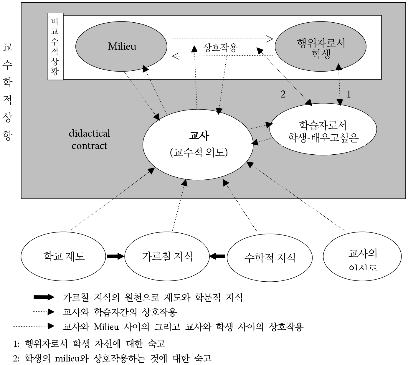
- Didactics in France has developed through Gérard Vergnaud’s Theory of conceptual fields, Guy Brousseau’s Theory of didactic situation, Yves Chevallard’s Theory of didactic transposition and Anthropological Theory of Didactics et al. Guy Brousseau firstly suggested didactical theory of French didactics, namely the theory of didactic situation which emphasize the role of situation in building knowledge, systematical cognitive behavior within situation and learning through this situation, Depending on the theory of learning by adaptation of Piaget, hypothesis of epistemological obstacle of Gaston Bachelard, the concept of milieu which contains all cultural knowings. the theory of didactic situation defines learning as combination of adaptation and acculturation, and emphasize devolution as a condition for adaptation and institutionalization as a condition for acculturation.
- COLLAPSE
프랑스에서 교수학은 교수학적 변환과정에 중점을 두고, Gérard Vergnaud의 개념장 이론, Guy Brousseau가 제시한 교수학적 상황론(Theory of didactic situation), Yves Chevallard가 제시한 교수학적 변환론(Theory of didactic transposition)과 교수학의 인류학적 접근(Anthropological Theory of Didactics) 등으로 발전해왔다. Guy Brousseau는 Piaget의 인지이론의 영향을 넘어서 프랑스적인 독자적 교수학이론을 처음으로 제시했다고 볼 수 있는데, 지식의 형성과정에서 상황의 중요성을 재인식하고, 상황 속에서의 인지적 행위들과 이 과정에서 발생하는 학습을 보다 체계적으로 조직하여 교수학적 상황론을 제시하였다. Brousseau의 교수학적 상황론은 Piaget의 적응에 의한 학습, Bachelard의 인식론적 장애 가설, 모든 문화적 앎을 담은 개념으로서 milieu를 바탕으로 하여, 교수와 학습의 체계적 성격, 지식의 인식론, 그리고 학습을 적응(adaptation)과 변용(acculturation)의 결합으로 보는 관점에 초점을 둔다. 비교수적(adidactical) 상황에서의 환경으로의 독립적 적응과 다른 한편으로 교수학적 상황과 협약을 통한 교육시스템으로의 변용을 촉진하도록 하기 위해, 적응을 위한 조건으로서 이양(devolution)과 변용(acculturation)을 위한 조건으로 제도화를 강조한다.
-
The Application of Theory of Didactical Transposition into Geography Instruction: Focusing on Theory of Didactic Situation
-
Research Article
-
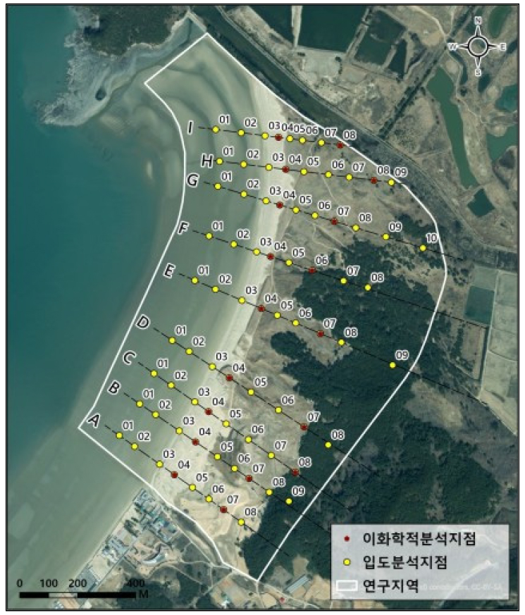
Sedimentary Environmental Characteristics of the Sinduri Coastal Dune System Based on Surface Sediment Analysis
표층 퇴적물 분석을 통한 신두리 해안사구지대의 퇴적 환경 특성
-
Geun-Bi Jeong · Kwang-Sung Yun · Dong-Ho Jang
정근비 · 윤광성 · 장동호
- This study investigates the spatial and seasonal variability of the sedimentary environment in the Sinduri coastal dune system through analyses of grain-size …
본 연구는 신두리 해안사구지대를 대상으로 표층 퇴적물의 입도 및 이화학적 특성을 분석하여 퇴적 환경의 공간적·계절적 변동 양상을 분석하였다. 표층 퇴적물 시료는 겨울·봄·여름철에 …
- This study investigates the spatial and seasonal variability of the sedimentary environment in the Sinduri coastal dune system through analyses of grain-size and physicochemical properties of surface sediments. Surface sediment samples were collected from sandy tidal flats, beaches, foredunes, interdune lowlands, and backdunes during winter, spring, and summer. Grain-size analysis revealed that medium sand was dominant throughout the study area, with a seasonal trend characterized by coarsening in spring and fining in summer. Spatially, a gradual fining trend from the coast toward inland areas was partially observed during winter; however, grain-size differences between the beach and adjacent dune units were relatively small. Physicochemical analyses showed that concentrations of exchangeable cations of marine origin decreased with increasing distance from the shoreline. Multivariate statistical analysis indicated that the first and second principal components accounted for 91.3% of the total variance, primarily reflecting variations in grain-size distribution and fine-grained sediment content. Cluster analysis further demonstrated that the spatial distribution of sedimentary characteristics varied seasonally, reflecting the combined influence of seasonal forcing and geomorphic settings.
- COLLAPSE
본 연구는 신두리 해안사구지대를 대상으로 표층 퇴적물의 입도 및 이화학적 특성을 분석하여 퇴적 환경의 공간적·계절적 변동 양상을 분석하였다. 표층 퇴적물 시료는 겨울·봄·여름철에 사질갯벌, 사빈, 전사구, 사구저지대, 후사구에서 채취하였다. 입도분석 결과, 연구지역 전체에서 중립사가 우세하였으며, 계절적으로는 봄철 조립화와 여름철 세립화 경향이 확인되었다. 공간적으로는 해안에서 내륙으로 갈수록 입도가 세립해지는 경향이 겨울철에 부분적으로 관찰되었으나, 사빈과 인접한 사구 지형 간의 입도 차이는 크지 않았다. 이화학적 분석 결과, 해수 기원의 치환성 양이온 농도는 해안선으로부터 거리가 증가함에 따라 감소하는 경향을 보였다. 다변량 통계 분석 결과, 제1·제2 주성분이 전체 분산의 91.3%를 설명하였으며, 이는 주로 입도 분포와 세립 성분 함량의 변동을 반영한다. 군집 분석을 통해 퇴적물의 공간 분포가 계절에 따라 차이를 확인하였으며, 이는 계절적 변동성과 지형적 조건의 복합적인 영향을 반영한다.
-
Sedimentary Environmental Characteristics of the Sinduri Coastal Dune System Based on Surface Sediment Analysis
-
Research Article
-
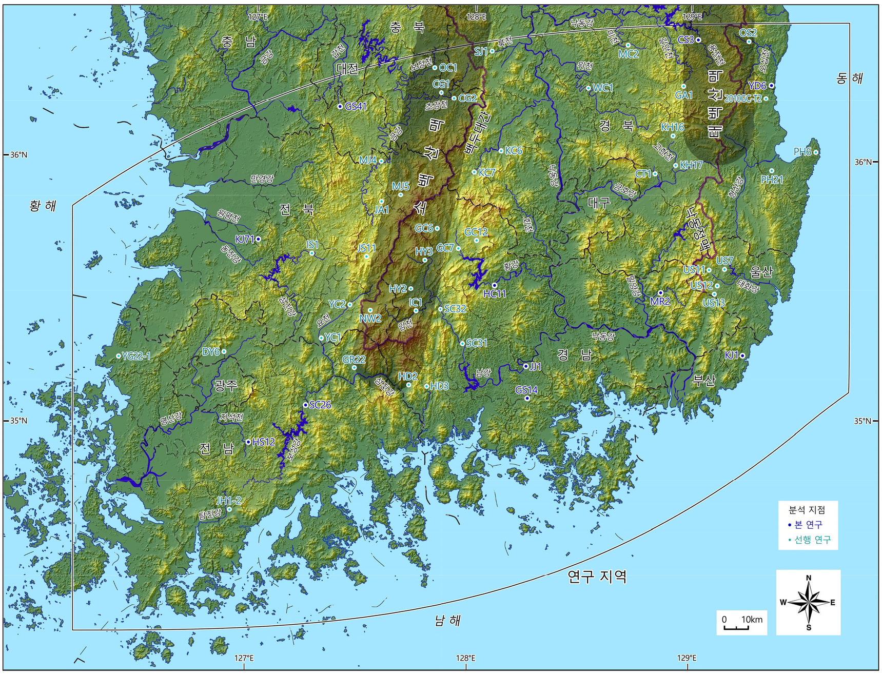
Distribution of Late Quaternary Incision Rates in the Southern Part of the Korean Peninsula
한반도 남부의 제4기 말 하각률 분포
-
Gwang-Ryul Lee
이광률
- During the Quaternary period, the Korean Peninsula underwent macroscopic changes of surface relief driven by tilted flexure uplifting and fluvial processes. This …
한반도에서는 신생대 제4기 동안에 경동성 요곡 융기 작용과 하천의 침식 및 퇴적 작용을 통해 지표 기복의 변화가 일어났다. 한반도 남부에서 총 53개 …
- During the Quaternary period, the Korean Peninsula underwent macroscopic changes of surface relief driven by tilted flexure uplifting and fluvial processes. This study analyzed the distribution of fluvial incision rates and the factors influencing them, targeting a total of 53 fluvial and fan terraces in the southern part of the Korean Peninsula. The results indicate that the highest incision rates are found in the southern Sobaek Mountains and the southernmost part of the Taebaek Mountains, areas characterized by high altitudes due to uplifting. Conversely, the lowest incision rates were observed in coastal areas and the lower reaches of major rivers close to base level of erosion. The shortest distance from the uplift axis mountains and the shortest distance from the base level of erosion showed the strongest correlation with incision rates. In southern Korea, fluvial incision becomes more active as the distance to the Sobaek or Taebaek Mountains decreases and the distance from the coastline or lower river channels increases. Furthermore, the Sobaek Mountains exhibited higher incision rates than the Taebaek Mountains, suggesting that fluvial incision was more vigorous in the Sobaek Mountains area during the late Quaternary.
- COLLAPSE
한반도에서는 신생대 제4기 동안에 경동성 요곡 융기 작용과 하천의 침식 및 퇴적 작용을 통해 지표 기복의 변화가 일어났다. 한반도 남부에서 총 53개 하안단구 및 선상지 단구 지형을 대상으로 하천 하각률의 분포와 하각에 영향을 미친 요인을 분석하였다. 한반도 남부에서 하각률이 가장 큰 곳은 융기를 통해 해발고도가 높은 소백산맥 남부와 태백산맥 최남단 일대이고, 하각률이 가장 작은 곳은 침식기준면과 고도차가 크지 않은 해안 및 대하천 하류부 일대로 나타났다. 융기축 산맥에서의 최단 거리와 침식기준면에서의 최단 거리는 하각률과 상관관계가 가장 높아서, 한반도 남부에서는 소백산맥 또는 태백산맥과 가까우면서 해안선 및 대하천 하류 하도와 멀수록 하천의 하각 작용이 활발해지는 것으로 나타났다. 그리고 소백산맥 중심부가 태백산맥 중심부보다 하각률이 더 커서, 제4기 말 동안에 한반도 남부에서는 태백산맥보다 소백산맥 일대에서 하천의 하각 작용이 더 활발하였다.
-
Distribution of Late Quaternary Incision Rates in the Southern Part of the Korean Peninsula
-
Research Article
-
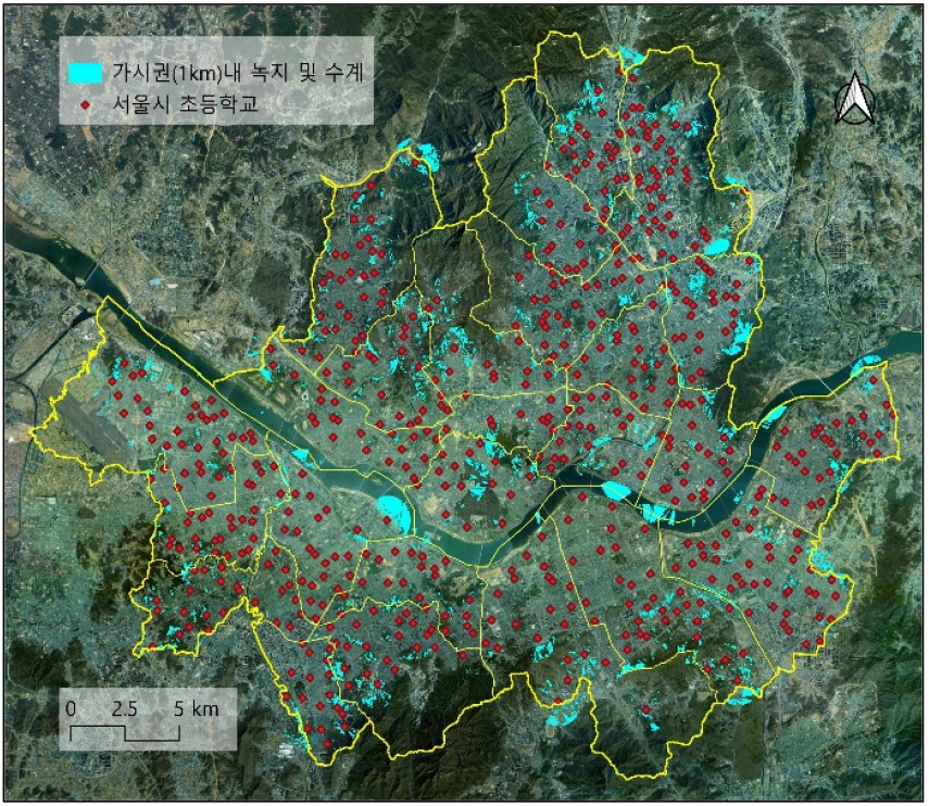
A Study on the Evaluation of Environmental and Ecological Resources in Seoul Elementary Schools
서울시 초등학교의 환경·생태자원 평가 연구
-
Youjin Hong
홍유진
- This study aims to quantitatively examine the spatial structure and equity of ecological environments surrounding elementary schools in a metropolitan context. Focusing …
본 연구는 대도시 초등학교 주변 생태환경의 공간적 구조와 형평성 문제를 정량적으로 규명하고자 하였다. 서울시 초등학교를 대상으로 학교 중심 500m 범위의 환경·생태자원을 분석하였으며, …
- This study aims to quantitatively examine the spatial structure and equity of ecological environments surrounding elementary schools in a metropolitan context. Focusing on elementary schools in Seoul, environmental and ecological resources within a 500-meter radius of each school were analyzed. Five indicators were constructed: landcover, NDVI, green connectivity, visible green ratio, and park accessibility distance. Principal component analysis revealed that environmental resources around schools are structured in a dual form, consisting of green–ecological resources and park accessibility. The results indicate that environmental resources surrounding elementary schools in Seoul are generally leveled at relatively low values, while spatial imbalances are concentrated in specific districts. High levels of green–ecological resources were observed along the peripheral natural green belt areas, whereas clusters of low values were identified in high-density inner-city and southwestern districts. In contrast, park accessibility did not correspond to the distribution of natural land cover and was found to be influenced primarily by urban planning and pedestrian network structures, indicating its character as an urban-type environmental resource. This study contributes by quantitatively operationalizing ecological environmental resources at the school-neighborhood scale and by proposing a diagnostic framework for assessing ecological conditions within school-centered micro-living areas. The findings provide foundational evidence to inform urban planning and education policy aimed at enhancing environmental equity for children.
- COLLAPSE
본 연구는 대도시 초등학교 주변 생태환경의 공간적 구조와 형평성 문제를 정량적으로 규명하고자 하였다. 서울시 초등학교를 대상으로 학교 중심 500m 범위의 환경·생태자원을 분석하였으며, 토지피복, NDVI, 녹지 연결성, 가시권 비율, 공원 접근거리의 5개 지표를 구축하였다. 주성분분석을 통해 학교 주변 환경자원이 녹지생태자원과 공원접근성이라는 이중 구조로 형성됨을 확인하였다. 분석 결과, 서울시 초등학교 주변 환경자원은 전반적으로 낮은 수준에 평준화되어 있으면서도 특정 권역에서 결핍이 집중되는 공간적 불균형을 보였다. 외곽의 자연녹지 축에서는 높은 녹지생태자원이 나타난 반면, 도심 및 남서부 고밀 지역에서는 낮은 값의 군집이 확인되었다. 한편 공원접근성은 자연피복 분포와 일치하지 않았으며, 도시계획 및 보행 네트워크 구조의 영향을 받는 도시형 환경자원임이 확인되었다. 본 연구는 초등학교 주변의 생태환경자원을 공간적 차원에서 계량화하였다는 점에서 의의를 가지며, 학교 중심 소생활권 단위의 생태환경 진단 틀을 제시함으로써 도시계획 및 교육정책 수립을 위한 기초자료를 제공한다.
-
A Study on the Evaluation of Environmental and Ecological Resources in Seoul Elementary Schools
-
Research Article
-
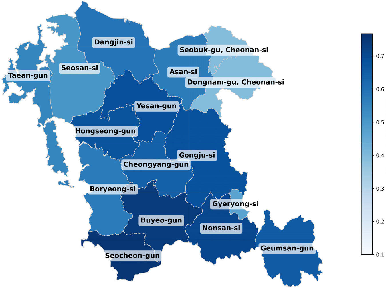
A Study on the Methodology for Quantifying Regional Matjip Attractiveness and Its Application
지역별 맛집 매력도의 정량화 방법론 연구와 적용
-
Ki-Won Lee · Jihoon Park · Hyung-Geun Jung
이기원 · 박지훈 · 정형근
- This study proposes a methodology to geographically quantify the “matjip attractiveness” of a region using NAVER search big data. We collected and …
본 연구는 네이버(NAVER) 검색 빅데이터를 활용해 지역의 맛집 매력도를 지리학적으로 정량화하는 방법론을 제시한다. 2016~2025년 충남 15개 시·군의 “지역명+맛집”의 일자별 검색량을 수집·전처리하고, ‘주간 …
- This study proposes a methodology to geographically quantify the “matjip attractiveness” of a region using NAVER search big data. We collected and preprocessed daily search volumes for the keyword combination “Region Name + Matjip” across 15 cities and counties in Chungcheongnam-do from 2016 to 2025. By defining ‘Weekly Mid-range Search Volume’ and ‘Weekend Search Volume Amplitude,’ we constructed scatter plots for analysis. From the linear pattern of the upper boundary of the scatter plots, we derived a maximum regression line, and from the overall data distribution, an average regression line. The slope and intercept of the maximum regression line were defined as the ‘Potential Attraction Rate’ and ‘Threshold,’ respectively, while the slope of the average regression line was defined as the ‘Actual Attraction Rate.’ Applying this methodology to the Chungcheongnam-do region revealed a distinct decoupling phenomenon between the Potential Attraction Rate and the residential population size, confirming it as an independent indicator that measures the region’s unique matjip attractiveness. In contrast, the Threshold exhibited a distinct inverted-U non-linear relationship with population size, which demonstrates the evolutionary process of regional commercial spheres from an ‘external-dependent type’ to a ‘self-sufficient mega-living sphere.’ Furthermore, an analysis of the ‘Realization Rate’ revealed that regional disparities in actual attractiveness relative to potential stem from the ‘structural asymmetry’ between daily routine demand and non-routine tourism demand, rather than mere variations in tourism drawing power. The proposed methodology is useful for regional classification and policy targeting by separating the dimension of psychological and cultural attractiveness from the demographic dimension of traditional Central Place Theory.
- COLLAPSE
본 연구는 네이버(NAVER) 검색 빅데이터를 활용해 지역의 맛집 매력도를 지리학적으로 정량화하는 방법론을 제시한다. 2016~2025년 충남 15개 시·군의 “지역명+맛집”의 일자별 검색량을 수집·전처리하고, ‘주간 검색량 중간값’과 ‘주말 검색량 진폭’을 정의하여 산점도를 구성했다. 산점도 상단 경계의 선형 패턴으로부터 최대회귀선을, 전체 데이터 분포로부터 평균회귀선을 구한 후, 최대회귀선 기울기와 x절편을 각각 ‘잠재매력율’과 ‘문턱값’으로, 평균회귀선의 기울기를 ‘실제매력율’로 정의하였다. 이 연구방법론을 충청남도 지역에 적용한 결과, 잠재매력율은 정주 인구 규모와 뚜렷한 탈동조화 현상을 보여 지역 고유의 맛집 매력도를 독립적으로 측정하는 지표임이 확인되었다. 반면, 문턱값은 정주 인구 규모와 뚜렷한 역U자형 비선형 관계를 보이며, 이를 통해 지역 상권이 ‘외부 의존형’에서 ‘자족형 거대 생활권’으로 진화하는 과정을 입증하였다. 또한 ‘실현율’ 지표를 통해 잠재 대비 실제 매력도의 지역별 편차는, 단순한 관광 유인력의 차이가 아닌 일상 수요와 비일상적 관광 수요 간의 ‘구조적 비대칭성’에 기인함을 규명하였다. 제안한 방법론은 전통적 중심지 이론의 인구 차원에 심리·문화 요인의 매력도 차원을 분리해내어, 지역 유형화와 정책 타겟팅에 유용하다.
-
A Study on the Methodology for Quantifying Regional Matjip Attractiveness and Its Application
-
Research Article
-
The Spatial Characteristics of AI Job Demand Using Online Job Postings
온라인 채용공고 정보를 활용한 AI 직무 채용 수요의 공간적 분포 특성
-
Yoonsik Chae · Sumin Ryu
채윤식 · 류수민
- This study analyzes the functional composition and spatial distribution of AI job demand in South Korea based on job-posting data from major …
본 연구는 민간 채용 플랫폼의 온라인 채용공고 데이터를 활용하여 국내 AI 직무 채용 수요의 기능적 구성과 공간적 분포를 분석하였다. 분석 결과, AI …
- This study analyzes the functional composition and spatial distribution of AI job demand in South Korea based on job-posting data from major online job portals. The results reveal a multi-layered AI job structure spanning model development, data/platform and software development, embedded and system roles, and infrastructure functions. Spatially, AI job demand is markedly concentrated in the Seoul Capital Area, particularly along the Gangnam (Seoul)–Seongnam (Gyeonggi) axis, with pronounced inter-regional disparities and statistically significant spatial clustering. Meanwhile, R&D as well as embedded and system-related functions show partial potential for dispersion outside the capital region. By identifying functional differentiation and spatial distribution at the job level, this study provides empirical insights into regional labor market dynamics and offers policy implications for place-based talent development.
- COLLAPSE
본 연구는 민간 채용 플랫폼의 온라인 채용공고 데이터를 활용하여 국내 AI 직무 채용 수요의 기능적 구성과 공간적 분포를 분석하였다. 분석 결과, AI 직무수요는 모델 개발, 데이터·플랫폼 및 소프트웨어 개발, 임베디드·시스템, 인프라 운영·통합 등으로 분화되는 다층적 구조를 보였다. 모든 직무수요에서 서울 강남-경기 성남 축을 중심으로 수도권 편중이 뚜렷하게 나타났으며, 지역 간 불균등성과 공간적 군집성이 함께 확인되었다. 반면 연구개발 및 임베디드·시스템 관련 직무수요에서는 일부 비수도권 지역으로의 분산 가능성도 관찰되었다. 본 연구는 채용공고 빅데이터를 활용해 AI 직무수요의 기능적 분화와 공간적 분포 특성을 직무 단위에서 분석함으로써, 지역 노동시장 분석과 지역 맞춤형 인재 정책 설계를 위한 실증적 근거를 제공한다.
-
The Spatial Characteristics of AI Job Demand Using Online Job Postings
-
Research Article
-
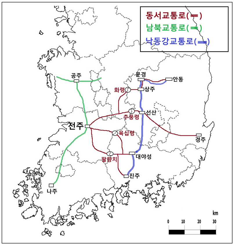
Characteristics of Formation of Military Transportation Route on Jeonju-Centered during the Later-Baekje Period
후백제 시기 전주 중심의 군사 교통로 형성 특징
-
Sungwook Cho
조성욱
- In this study, the structure of transportation routes centered on Jeonju, the capital of the Later Baekje (900~936), was examined, focusing on …
이 연구에서는 군사 교통로를 중심으로 후삼국시대 후백제(900~936)의 수도였던 전주 중심의 교통로 구조를 살펴보았다. 후삼국시대의 교통로는 통일신라시대에 경주를 중심으로 9주와 5소경을 연결했던 행정 …
- In this study, the structure of transportation routes centered on Jeonju, the capital of the Later Baekje (900~936), was examined, focusing on military transportation routes. The transportation route of the Later-Three Kingdoms period was based on the administrative-oriented transportation route that connected 9 administrative district and 5 small capital around Gyeongju during the Unified Silla Period. And the transportation route was developed around Gyeongju in Silla, Gaegyeong in Goryeo, and Jeonju in Later-Baekje. Unlike Baekje and Silla during the Three Kingdoms period, which confronted each other in the east-west direction around the Sobaek Mountains, but the Sobaek Mountains did not act as a special obstacle to transportation during the Later-Three Kingdoms period. Later-Baekje used four East-West transportation routes: a route to Sangju through Hwaryeong (Pass), a route to Seonsan through Chupungryeong (Pass), and a route to Daeya Castle and Jinju area through Yukshipryeong (Pass) and Palyangchi (Pass). And the major North-South transportation route was a formed along the Nakdong River from Andong in the north to Jinju in the south. This route was a major battleground for Later-Baekje versus Silla and Goryeo. While Later-Baekje's East-West transportation route remained relatively stable, but the North-South transportation route along the Nakdong River became a major battleground for the three countries.
- COLLAPSE
이 연구에서는 군사 교통로를 중심으로 후삼국시대 후백제(900~936)의 수도였던 전주 중심의 교통로 구조를 살펴보았다. 후삼국시대의 교통로는 통일신라시대에 경주를 중심으로 9주와 5소경을 연결했던 행정 중심의 교통로를 근간으로, 신라는 경주, 고려는 개경 그리고 후백제는 전주 중심으로 교통로가 형성되었다. 소백산맥을 중심으로 동서 방향으로 대결했던 삼국시대의 백제 및 신라와는 달리, 후삼국시대에는 소백산맥이 경계 역할을 하지는 않았다. 후백제는 동서 교통로 4개를 활용했는데, 화령을 통과하여 상주로 이동하는 노선, 추풍령을 통과하여 선산으로 이동하는 노선, 육십령과 팔량치를 통과하여 합천 대야성과 진주 지역으로 이동하는 노선이었다. 그리고 주요 남북 교통로는 낙동강을 따라 북부의 안동에서 남쪽의 진주 지역까지 형성된 노선으로, 이 노선은 후백제와 신라 및 고려의 주요 격전지였다. 후백제의 동서 교통로가 비교적 안정적으로 유지된 데 비하여, 낙동강을 따라 형성된 남북 교통로는 후삼국의 주요 격전지였다.
-
Characteristics of Formation of Military Transportation Route on Jeonju-Centered during the Later-Baekje Period
-
Research Article
-
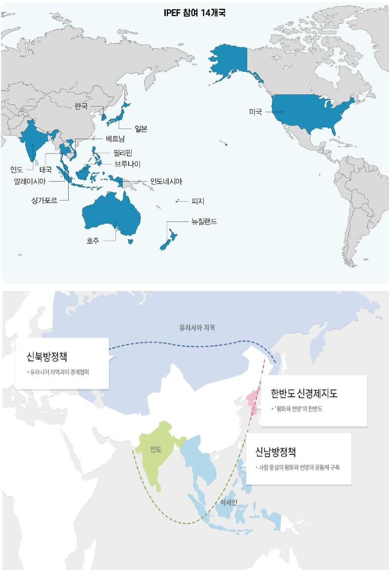
Revisiting Geographic Literacy as the Foundation of Foreign Policy: Cognitive Misperceptions of the Indo-Pacific Region
외교 정책의 기초로서 지리적 문해력 재조명: 인도-태평양 지역에 대한 인지 오류 문제를 중심으로
-
Eje Kim · Changhwan Kim
김이재 · 김창환
- This study examines cognitive misperceptions of the Indo-Pacific region amid intensifying U.S.–China competition and reconsiders geographic literacy as a foundational capacity for …
본 연구의 목적은 미·중 패권 경쟁이 심화되는 국제질서 속에서 인도-태평양 지역이 핵심 지정학적 공간으로 부상하는 과정에 주목하고, 외교정책의 기초 역량으로서 지리적 문해력의 …
- This study examines cognitive misperceptions of the Indo-Pacific region amid intensifying U.S.–China competition and reconsiders geographic literacy as a foundational capacity for foreign policy. The Trump administration’s Indo-Pacific strategy reflects a revival of geopolitical thinking, prioritizing spatial control, strategic connectivity, and maritime routes over liberal norms and multilateral frameworks. This shift underscores the growing importance of spatial awareness in both policy-making and public understanding. To assess cognitive gaps related to South Korea's New Southern Policy and the Indo-Pacific Economic Framework (IPEF), a survey of 350 university students was conducted. The findings reveal significant confusion regarding policy target countries, ASEAN membership, IPEF participation, and the meaning of the Indo-Pacific concept. Notably, students from teachers' colleges showed consistently lower accuracy than geography majors. These misperceptions are associated with the marginalization of geography education, Western-centric curricula, and limited map-based learning. This study argues that strengthening geographic literacy is essential for improving foreign policy effectiveness and calls for systematic training for diplomats and public officials, along with enhanced geography education in both formal and lifelong learning contexts.
- COLLAPSE
본 연구의 목적은 미·중 패권 경쟁이 심화되는 국제질서 속에서 인도-태평양 지역이 핵심 지정학적 공간으로 부상하는 과정에 주목하고, 외교정책의 기초 역량으로서 지리적 문해력의 중요성을 재조명하는 것이다. 트럼프 행정부의 인도-태평양 전략은 규범 중심의 자유주의 국제질서 유지보다는 공간 통제, 전략적 연결망 재편, 해상로 및 병목 지점 확보를 중시하는 지정학적 사고의 부활을 보여준다. 이러한 변화는 외교정책 수립뿐 아니라 대중적 이해의 차원에서도 지리적 개념과 공간 인식의 중요성을 부각시킨다. 본 연구는 한국의 신남방정책과 인도-태평양 경제 프레임워크(Indo-Pacific Economic Framework, IPEF)를 둘러싼 인지 오류를 파악하기 위해 전국 대학생 350명을 대상으로 지리적 문해력 수준을 평가하였다. 분석 결과, 신남방정책 대상국, 동남아시아 국가연합(ASEAN) 범주, IPEF 참여 지역, 인도-태평양 개념에 대한 이해에서 상당한 혼선이 확인되었으며, 특히 교육대학교 학생들의 정답률이 상대적으로 낮게 나타났다. 이러한 인지 오류는 지리교육 축소, 서구중심적 교육과정, 지도 기반 학습 부족 등 공교육의 구조적 요인과 관련된 것으로 해석된다. 본 연구는 외교정책의 실효성 제고를 위해 외교관 및 공무원 대상 지리적 문해력 재교육과 함께, 국가 교육과정 및 평생교육 차원에서 인도-태평양 지역에 대한 정확한 공간 인식을 강화하는 지리교육 확대를 제안한다.
-
Revisiting Geographic Literacy as the Foundation of Foreign Policy: Cognitive Misperceptions of the Indo-Pacific Region

Journal Informaiton
 Journal of the Association of Korean Geographers
Journal of the Association of Korean Geographers


한국지리학회
105, Academic Affairs Office, 1st floor, College of Education, Dongguk University, Hakrim Hall (J Building), 30, Pildong-ro 1-gil, Jung-gu, Seoul 04620, Korea
Tel: +82-2-2260-3108 / Fax: +82-2-2260-3113 / E-mail: geography.akg@gmail.com Copyright© The Association of Korean Geographers. Powered by APUB
Tel: +82-2-2260-3108 / Fax: +82-2-2260-3113 / E-mail: geography.akg@gmail.com Copyright© The Association of Korean Geographers. Powered by APUB