
-
Research Article
-
Development and Implementation of a Student-Centered Climate Change Response Competence Program
학습자 활동 중심 기후변화 대응 역량 프로그램 개발과 적용
-
Minsung Kim
김민성
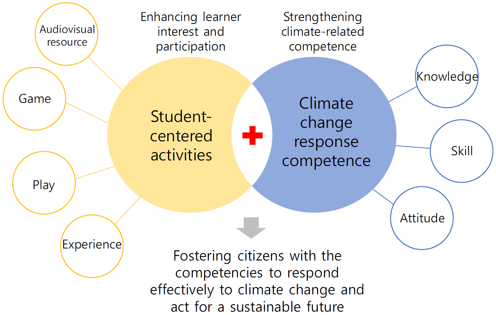
- The purpose of this study was to develop a climate change education program designed to foster climate change response competence, defined as …
이 연구의 목적은 기후 재난이 발생했을 때의 대처 방법, 지속가능한 미래를 대비하는 지식, 기능, 태도를 포함하는 총체적 역량으로 정의되는 기후변화 대응 역량을 …
- The purpose of this study was to develop a climate change education program designed to foster climate change response competence, defined as a comprehensive capacity that includes how to cope with climate disasters as well as the knowledge, skills, and attitudes needed to prepare for a sustainable future, and to examine its effects. The program consisted of five learning modules: understanding climate change, surviving floods, escaping heatwaves, coping with cold waves, and an “Save the Earth” action module. To promote active, student-centered learning, the program incorporated a range of audiovisual materials and games to support engaging participation. When the program was implemented with elementary and secondary students, participants’ responses were overall positive. Students reported that the lessons were enjoyable and easy to understand. They also indicated that they learned how to act in climate-crisis situations and showed stronger intentions to take action to protect the environment. In addition, students perceived the program as beneficial and expressed a desire to take similar lessons in the future. This study is significant because it developed a concrete climate change response competence program spanning multiple grade levels and empirically examined participants’ responses.
- COLLAPSE
이 연구의 목적은 기후 재난이 발생했을 때의 대처 방법, 지속가능한 미래를 대비하는 지식, 기능, 태도를 포함하는 총체적 역량으로 정의되는 기후변화 대응 역량을 함양하기 위한 기후변화교육 프로그램을 개발하고 그 효과를 검증하는 것이다. 개발한 학습모듈의 주제는 기후변화 이해하기, 홍수에서 살아남기, 폭염에서 탈출하기, 한파에서 벗어나기, 지구 구출 대 작전이었다. 학생들이 흥미롭게 학습에 참여할 수 있도록 다양한 시청각 자료, 게임 등을 포함하고 적극적 활동에 기반한 학습자 중심 학습이 가능하도록 설계하였다. 해당 프로그램을 초중등 학생들에게 적용한 결과, 참여자들의 반응은 전반적으로 긍정적이었다. 학생들은 본 프로그램의 수업이 재미있고, 이해하기 쉬웠다는 반응을 보였다. 기후 위기 상황에서 어떻게 행동해야 할지 알게 되었고, 환경 보호를 위해 행동하려는 의지를 높이는 모습을 높였다. 나아가 본 프로그램 참여를 유익하게 생각했으며 이런 수업을 더 받고 싶다고 하였다. 이 연구는 다양한 학령을 아우르는 기후변화 대응 역량 프로그램을 개발하고 참여자의 반응을 실증적으로 조사했다는 점에서 의미가 있다.
-
Development and Implementation of a Student-Centered Climate Change Response Competence Program
-
Research Article
-
How Is ‘Economic Geography’ Being Inherited?: Focusing on 「Global Citizenship and Geography」 and 「Korean Geography: an Inquiry」 in the 2022 Revised Curriculum
‘경제지리’는 어떻게 계승되고 있는가?: 2022 개정교육과정 「세계시민과 지리」와 「한국지리 탐구」를 중심으로
-
Na-mi Chae ⋅ Jeong-won Seong
채나미 · 성정원
- his study compares and analyzes 「Economic Geography」 in the 7th National Curriculum with 「Global Citizenship and Geography」 and 「Korean Geography: An Inquiry …
본 연구는 차기 교육과정에서 경제지리가 새로운 선택과목으로 개발될 경우 포함해야 할 내용 요소와 방향성을 탐색하고자 7차 교육과정의 「경제지리」와 2022 개정 교육과정의 「세계시민과 …
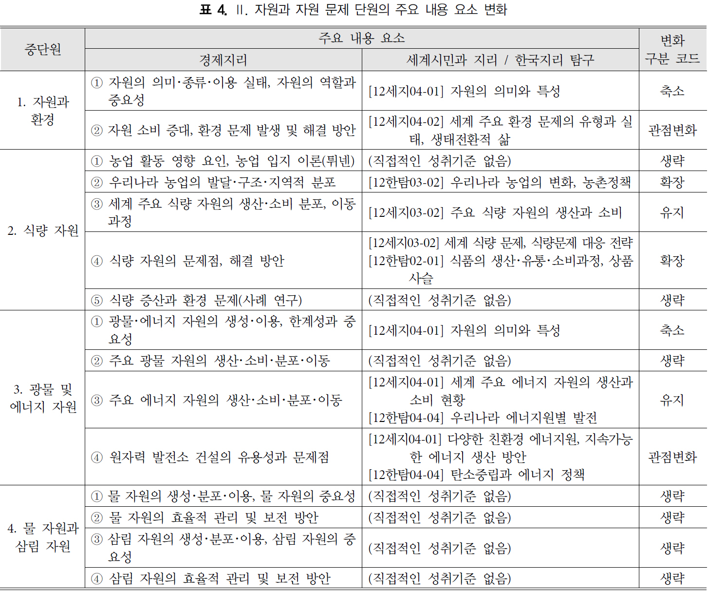
- his study compares and analyzes 「Economic Geography」 in the 7th National Curriculum with 「Global Citizenship and Geography」 and 「Korean Geography: An Inquiry Approach」 in the 2022 Revised Curriculum, in order to explore the content elements and direction of economic geography as a possible new elective subject in the next curriculum. The findings show that topics that remain socially important today, such as food resources, energy resources, and the role of multinational corporations, have been maintained. In addition, topics such as economic cooperation among countries under globalization, changes in Korean agriculture, and solutions to food problems have been inherited in an expanded form. Issues such as disparities between countries and regions, environmental and energy problems, and transportation and information and communication industries have been inherited through a shift in perspective toward spatial equity and ecological transition-oriented ways of life. In addition, topics such as mineral resources, the structure of world trade, and national land development plans were reduced to a focus on key cases and real-world issues. In contrast, core theories of economic geography, including agricultural location theory, industrial location theory, central place theory, and trade theory, were largely omitted, accounting for 51.6% of the total content elements. This study is significant because it identifies the traditional content elements that should be inherited and the modern content elements that should be newly included when developing economic geography as a new elective subject in the next curriculum. The findings can serve as basic data for future discussions on reintroducing economic geography into the school curriculum.
- COLLAPSE
본 연구는 차기 교육과정에서 경제지리가 새로운 선택과목으로 개발될 경우 포함해야 할 내용 요소와 방향성을 탐색하고자 7차 교육과정의 「경제지리」와 2022 개정 교육과정의 「세계시민과 지리」 및 「한국지리 탐구」를 비교 분석하였다. 연구 결과를 보면 식량 자원, 에너지 자원, 다국적 기업의 역할 등 오늘날에도 사회적 중요성이 높은 주제는 유지되었으며, 세계화에 따른 국가 간 경제 협력, 우리나라의 농업 변화, 식량 문제 해결 등은 확장된 형태로 계승되었다. 국가 및 지역 간 격차, 환경 및 에너지 문제, 교통과 정보 통신 산업 등은 공간적 형평성, 생태 전환적 삶 등의 관점변화 형태로 계승되었다. 그리고 광물자원, 세계 무역 구조, 국토 개발 계획 등은 핵심 사례와 현실 문제 중심으로 축소되었으며, 농업 입지론, 공업 입지론, 중심지 이론, 무역 이론 등 경제지리의 핵심 이론들은 상당 부분 삭제되었으며 그 비중이 51.6%에 달한다. 본 연구는 차기 교육과정에서 경제지리를 새로운 선택과목으로 개발하기 위해 계승해야 할 전통적 내용 요소와 새롭게 포함해야 할 현대적 내용 요소를 확인하였다는 점에서 의의를 가지며, 향후 경제지리 교과 재도입 논의를 위한 기초 자료로 활용될 수 있을 것이다.
-
How Is ‘Economic Geography’ Being Inherited?: Focusing on 「Global Citizenship and Geography」 and 「Korean Geography: an Inquiry」 in the 2022 Revised Curriculum
-
Research Article
-
Reconceptualizing Digital Sense of Place in Geography Education: Asymmetric Condition-Setting of Code-Mediation and the DSoP-3L Model
디지털 장소감의 지리교육적 재개념화: 코드매개의 비대칭적 조건설정과 DSoP-3L 모형
-
Hyungi Cho
조현기
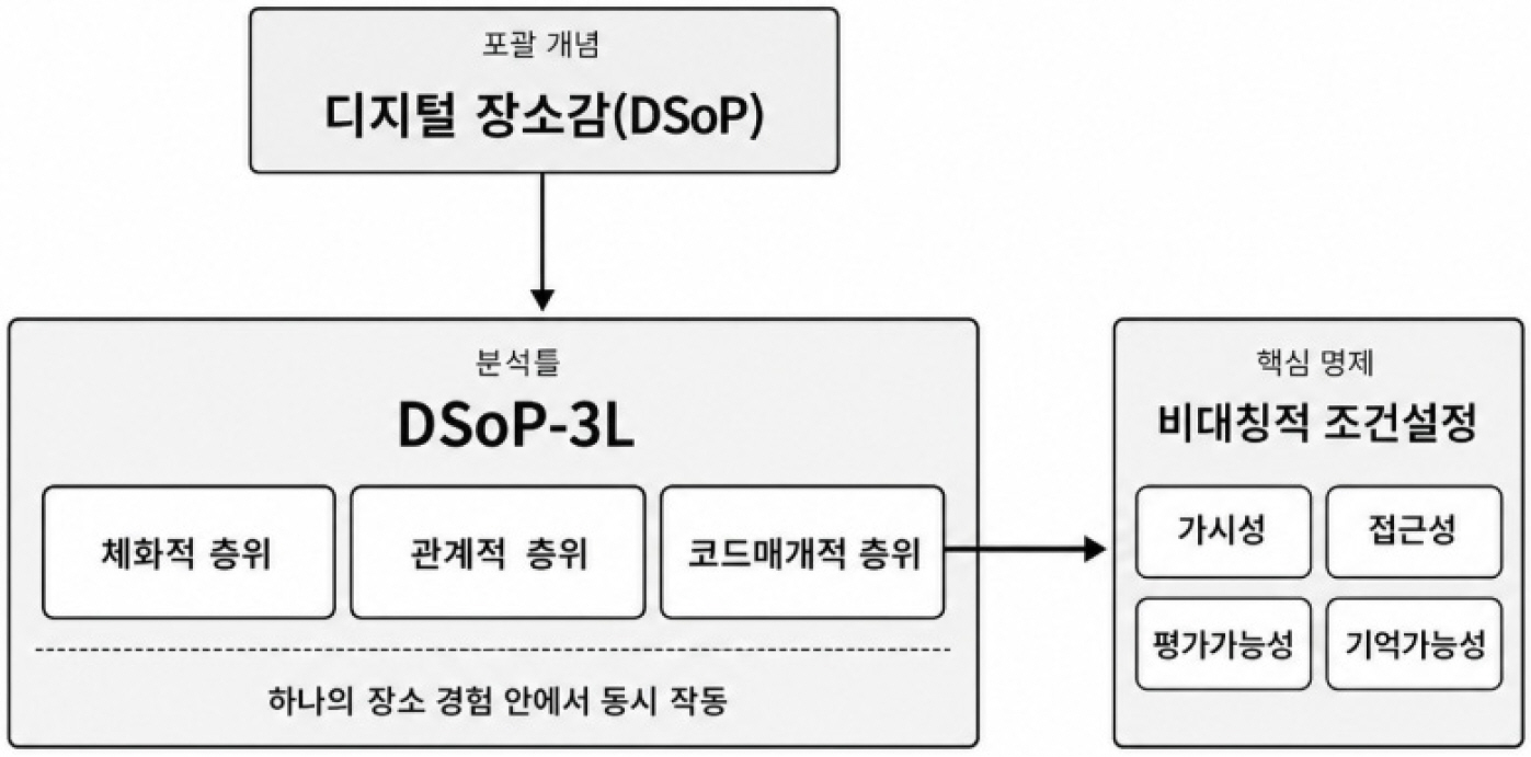
- This paper reconceptualizes digital sense of place (DSoP) as an analytical language for geography education. Rather than reporting classroom implementation or student …
본 연구는 실제 수업 실행이나 학생 자료 분석에 근거한 경험 연구가 아니라, 디지털 장소감(Digital Sense of Place, DSoP)을 지리교육의 분석 언어로 재개념화하는 …
- This paper reconceptualizes digital sense of place (DSoP) as an analytical language for geography education. Rather than reporting classroom implementation or student data analysis, it is designed as a conceptual literature study and a theoretical model-building inquiry. The proposed DSoP-3L model analyzes students’ place experiences through embodied, relational, and code-mediated layers that operate within the same place experience. Its central contribution is the thesis of asymmetric condition-setting: code-mediation through platforms, algorithms, data, interfaces, and defaults conditions how places become visible, accessible, evaluable, and memorable. By comparing DSoP-3L with Dai and Liu’s (2024) physical-digital-hybrid typology and Sun et al.’s (2026) five-subsystem model, the paper argues that DSoP-3L is not another tripartite typology but a layer-based analytical grammar for interpreting student utterances, fieldwork records, platform-map comparisons, and reflective writings. The Seongsu-dong café street is presented as a lesson-design scenario, not as evidence of instructional effects. The study proposes DSoP-3L as a question framework linking place-based learning, platform map literacy, critical place education, and digital memory education.
- COLLAPSE
본 연구는 실제 수업 실행이나 학생 자료 분석에 근거한 경험 연구가 아니라, 디지털 장소감(Digital Sense of Place, DSoP)을 지리교육의 분석 언어로 재개념화하는 개념적 문헌 연구이자 이론적 모형 제안 연구이다. DSoP-3L은 학생의 장소 경험을 하나의 장소 경험 안에서 동시에 작동하는 체화적·관계적·코드매개적 층위로 분석한다. 핵심 기여는 플랫폼·알고리즘·데이터·인터페이스·기본값을 통한 코드매개가 장소의 가시성·접근성·평가가능성·기억가능성을 비대칭적으로 조건설정한다는 명제를 정식화한 데 있다. Dai and Liu(2024)의 물리적·디지털·하이브리드 유형론 및 Sun et al.(2026)의 다섯 하위체계 통합 모형과 비교하여, DSoP-3L이 또 하나의 삼분 모형이 아니라 학생 발화, 답사 기록, 플랫폼 지도 비교, 성찰문을 해석하기 위한 층위 분석 문법임을 논증한다. 성수동 카페거리 논의는 실제 수업 효과 검증이 아니라 플랫폼화된 장소 읽기의 수업 설계 시나리오로 제시된다. 이를 통해 본 연구는 DSoP-3L을 장소기반학습, 플랫폼 지도 리터러시, 비판적 장소교육, 디지털 기억 교육을 연결하는 질문틀로 제안한다.
-
Reconceptualizing Digital Sense of Place in Geography Education: Asymmetric Condition-Setting of Code-Mediation and the DSoP-3L Model
-
Research Article
-
A Headship Rate-Based Framework for Small-Area Household Projections and an Assessment of Its Applicability
가구주율법에 의한 소지역 장래가구추계 프레임워크의 정립과 적용 가능성 분석
-
Daeheon Cho
조대헌
- This study aims to establish a framework for applying the headship-rate method, primarily used for national and provincial household projections, to small …
이 연구는 우리나라의 광역 단위에 공식적으로 사용되는 가구추계 기법인 가구주율법을 소지역(시군구)에 적용하기 위한 프레임워크를 정립하고, 그 적용성을 실증 분석하는 것을 목적으로 한다. …
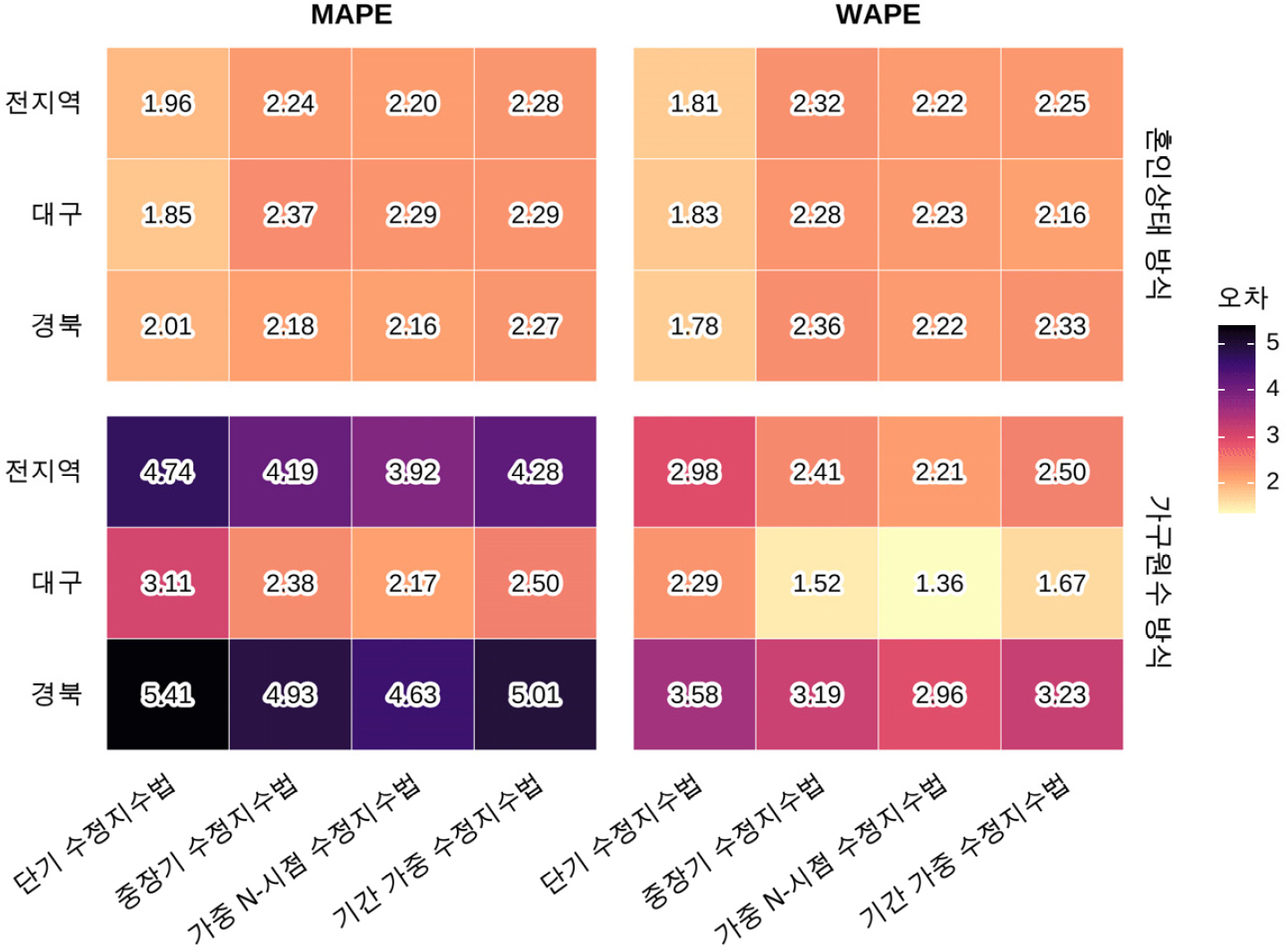
- This study aims to establish a framework for applying the headship-rate method, primarily used for national and provincial household projections, to small areas (si-gun-gu), and to empirically assess its applicability. Eight alternatives were formulated by combining two subpopulation frameworks—age by marital status and age by household size—with four modified exponential methods. These were applied to project 2022–2024 households in Daegu and Gyeongbuk municipalities, with the results compared against observed data. The results show that, based on the best-performing methods, projection errors ranged from approximately 2% to 4%, confirming the applicability of the headship-rate method to small-area household projections. The marital-status approach showed relatively low and stable errors when combined with the short-term modified exponential method, whereas the household-size approach performed better in large cities when combined with the weighted N-point modified exponential method. In terms of spatial error patterns, the household-size approach exhibited positive spatial autocorrelation, indicating spatial clustering of similar errors, while no clear spatial clustering was observed for the marital-status approach. Error decomposition and correlation analyses further showed that assumptions about future headship rates and total population, changes in the growth trend of small households, and regional population size were closely associated with regional differences in projection errors. This study demonstrates the applicability and limitations of extending the headship-rate method to small-area household projections and suggests that projection methods should be selected flexibly according to regional characteristics and policy purposes.
- COLLAPSE
이 연구는 우리나라의 광역 단위에 공식적으로 사용되는 가구추계 기법인 가구주율법을 소지역(시군구)에 적용하기 위한 프레임워크를 정립하고, 그 적용성을 실증 분석하는 것을 목적으로 한다. 이를 위해 연령·혼인상태 및 연령·가구원수 기준의 2가지 집단 구분과 4가지 수정지수법을 결합하여 모두 8개 실행 대안을 설정하였다. 이어 대구·경북 시군구를 사례지역으로 하여 2022–2024년 가구 수를 추계하고, 실제 자료와 비교하였다. 분석 결과, 최적 방법 기준으로 오차는 평균 2~4% 정도로 소지역에 대한 가구주율법 적용의 유효성이 확인되었다. 세부적으로 보면 혼인상태 기반 추계는 단기 수정지수법과 결합할 때 전반적인 오차가 낮고 안정적이었다. 하지만 가구원수 방식은 가중 N-시점 수정지수법 적용 시 규모가 큰 지역에서 상대적으로 우수한 성능을 보였다. 오차의 공간분포에서는 가구원수 방식이 양의 공간적 자기상관을 보이며 군집하는 경향을 나타낸 반면, 혼인상태 방식은 뚜렷한 군집성이 확인되지 않았다. 오차 발생의 주된 요소는 미래 가구주율과 전체 인구 설정에 있었으며, 소형가구 증가 추세의 변동성 및 지역 규모가 지역별 오차 크기와 밀접하게 관련되었다. 본 연구는 가구주율법의 소지역 확장 가능성을 규명하였으며, 지역 특성과 정책 목적에 따라 추계 방식을 선택적으로 활용할 필요가 있음을 시사한다.
-
A Headship Rate-Based Framework for Small-Area Household Projections and an Assessment of Its Applicability
-
Research Article
-
The Urban Image and Imaginative Geography of Seoul in the 1970s~80s focused on 「The Solitary Room」 by Kyung-sook Shin
신경숙의 「외딴방」에 나타난 1970~80년대 서울의 도시이미지와 심상지리
-
Sungsine Pak
박성신
- Human beings establish relationships with space and construct Sense of Place and Placeness throughout their lives. The autobiographical novel 「The Solitary Room」 …
인간은 삶의 과정에서 공간과 관계를 맺고 장소성을 구축한다. 「외딴방」 은 열여섯살의 신경숙의 1978년부터 1981년까지 4년 동안 초기 서울살이에 대한 자전적 소설로, 작가의 …
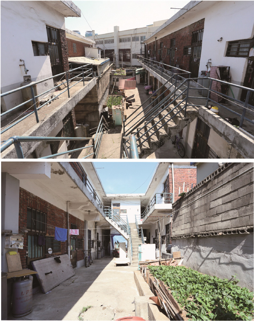
- Human beings establish relationships with space and construct Sense of Place and Placeness throughout their lives. The autobiographical novel 「The Solitary Room」 depicts a four-year period in the life of sixteen-year-old Shin Kyung-sook, who relocated to Seoul. This study examines the mental imagery and spatial characteristics of urban spaces as categorized according to the author’s daily movements and the spatial trajectories. The author’s residential space, the ‘Beoljip’, was an unauthorized building that lacked minimum living standards and housing rights and was perceived not as a home but as temporary lodging and a space of othering. The factory, the author’s labor space was a mechanized environment that normalized the division of labor and codification based on production speed, where the ‘Female Worker No. 1 on Line A’ suffered from restricted social relationships. While the Special Industrial Class provided a platform for a girl nurturing her literary dreams, it also served as an instrumental space in order to attain capitalism and economic development at the expense of rural youth. Furthermore, everyday spaces, such as markets and alleys were urban environments in which a teenage girl endured a grueling life under patriarchal gender norms. Seoul in the 1970s and 1980s was a metropolis of inherent contradictions. Through the binary opposition between her hometown, Jeongeup and Seoul; representing rural vs. urban, premodern vs. modern, and communal solidarity vs. anonymous individuals, the contradictions of the era were intensified, foreshadowing future polarization. Simultaneously, this environment provided the momentum for her to form subjectivity and growth. Ultimately, the urban image of Seoul converges on the ‘Solitary Room,’ symbolizing urban alienation. The urban spaces in the novel provide a crucial point of entry for understanding modernization, which served as both the foundation of individual life and the dominant goal of the respective era.
- COLLAPSE
인간은 삶의 과정에서 공간과 관계를 맺고 장소성을 구축한다. 「외딴방」 은 열여섯살의 신경숙의 1978년부터 1981년까지 4년 동안 초기 서울살이에 대한 자전적 소설로, 작가의 일상동선과 공간 성격에 따라 구분한 도시공간에 드러난 심상과 공간적 특성을 도출할 수 있다. 주거공간 벌집은 최소 거주면적과 주거권이 확보되지 못한 채 임대수익만을 추구하는 불법건축물로, 임시숙소이자 타자화된 공간으로 인식된다. 일터였던 공장은 기계화된 노동공간으로 생산의 속도에 따른 분업화와 기호화를 당연시하며, 공장에서 이름을 잃어버린 A라인 1번 여공은 사회적 관계를 제한받는다. 산업체특별학급은 일학년 사반 여학생에게 작가의 꿈을 키워나갔던 교육공간이었으나, 농촌과 지방 청년층의 희생을 전제로 한 자본주의와 경제발전을 도모하는 도구화된 공간이기도 하다. 또한 일상생활공간인 시장과 골목길은 십 대 소녀가 고단한 일상을 반복하는 가부장적 젠더 관념적 도시공간이다. 1970~80년대 서울은 급속한 산업화와 도시화의 중심에서 성장한 대도시로, 원초적 모순이 내재되어 있다. 고향 정읍과 타향 서울은 농촌과 도시, 전근대와 근대, 공동체적 연대와 익명의 개인으로 표출되는 이항대립적 구도를 통해 시대와 공간의 모순을 심화시키며, 미래 양극화를 예고함과 동시에 역설적으로 정체성을 형성하며 주체적으로 성장하는 계기를 제공했다. 이러한 모순 속 산업화와 도시화의 과정에서 서울의 도시이미지는 결국 ‘외딴방’이라는 도시 소외에 다다른다. 「외딴방」의 배경이 되는 도시공간은 개인의 삶의 터전이자 시대적 지향점이었던 근대화를 이해할 수 있는 단초가 된다.
-
The Urban Image and Imaginative Geography of Seoul in the 1970s~80s focused on 「The Solitary Room」 by Kyung-sook Shin
-
Research Article
-
Other(wise) Futurings of Smart City: Cities and Collective Human (Counter-) Intelligence
스마트 시티의 또 다른 미래 구상: 도시와 집단 인간 (반-)지성
-
Jin-Kyu Jung ⋅ Santiago Lopez ⋅ Bo Ae Chun ⋅ Gunwha Oh
정진규 · 산티아고 로페즈 · 전보애 · 오건화
- This paper sketches out ideas of critical techno-social praxis toward alternative relations with data and cities, conceptualizes other(wise) futures of smart cities …
이 논문은 현재 알려져 있는 스마트 시티의 이론과 실천을 예리하게 주시하면서, 데이터 및 도시와의 다른 관계를 지향하는 비판적 기술-사회적 실천(critical techno-social praxis)의 …
- This paper sketches out ideas of critical techno-social praxis toward alternative relations with data and cities, conceptualizes other(wise) futures of smart cities while remaining attentive to current theories and practices of smart cities. It responds to the questions of how the production of new digital technology and new forms/formations of innovative activities fit into the existing urban fabrics and how we can re-imagine and create alternative multiple visions for enabling smart cities and smart urbanism grounded in resources, priorities, and embodied knowledges of community. We connect such questions to the broader possibilities for an inclusive, equitable, participatory, and creative community-sensitive smart city. We think about the technical/technological infrastructures and platforms of the city, the stakes of smart citizenship, smart urbanism, and re-conceptualizations of AI other than artificial intelligence, to further think about the modes of smart engagement within the digitally mediated society that smart cities of the future might look like. It is also a call for a kind of techno-social relational praxis yet to emerge—representing urban spatial knowledge and complexity in ways that do not obscure but strive to center the generative, reflexive, and inclusive aspects in the development of collectively intelligently generated spatial information, artificial or not.
- COLLAPSE
이 논문은 현재 알려져 있는 스마트 시티의 이론과 실천을 예리하게 주시하면서, 데이터 및 도시와의 다른 관계를 지향하는 비판적 기술-사회적 실천(critical techno-social praxis)의 구상을 제시하고 스마트 시티의 ‘또 다른(otherwise)’ 미래를 개념화한다. 이는 새로운 디지털 기술의 생산과 혁신적 활동의 새로운 형태 및 구조가 기존의 도시 조직 속에 어떻게 자리 잡는지에 대한 질문에 답하고 있다. 또한, 지역사회의 자원, 우선순위, 그리고 내재된 지식에 기반하여 스마트 시티와 스마트 어바니즘을 실현하기 위한 대안적이고 다층적인 비전을 어떻게 새롭게 구상하고 창출할 수 있을지에 대해서도 다룬다. 이러한 질문들은 포용적이고 공정하며 참여적이고 창의적일 뿐만 아니라, 지역사회공동체의 특성을 존중하는 스마트 도시가 지닌 더 폭넓은 가능성과 연결한다. 이 논의는 스마트 시티의 미래가 구현될 디지털 매개 사회 속에서의 스마트 참여의 방식들을 고찰하기 위해, 도시의 기술적 (technical/technological) 인프라와 플랫폼, 스마트 시민권과 스마트 어바니즘, 그리고 ‘인공지능(Artificial Intelligence)’이 아닌 다른 관점에서의 AI에 대한 재개념화를 다룬다. 이는 또한 아직 등장하지 않은 일종의 기술-사회적 관계형 실천에 대한 요구이기도 하다. 즉, 인공적이든 아니든 집단적으로, 지성적으로 생성된 공간 정보 개발에서 생성적, 반사적, 포괄적인 측면을 모호하지 않고 중심에 두도록 노력하는 방식으로 도시 공간 지식과 복잡성을 표현하는 것이라 할 수 있다.
-
Other(wise) Futurings of Smart City: Cities and Collective Human (Counter-) Intelligence
-
Research Article
-
Assessment of OpenStreetMap Road Network Completeness and Positional Accuracy: A Case Study of Hwaseong Special City
오픈스트리트맵 도로망 완성도 및 정확도 평가: 화성특례시를 사례로
-
Ilyoung Hong
홍일영
- This study evaluates the completeness and positional accuracy of the OpenStreetMap (OSM) road network in four districts of Hwaseong Special City by …
본 연구는 화성특례시 4개 권역을 대상으로 OpenStreetMap(OSM) 도로망의 완성도와 위치 정확도를 국토지리정보원 공식 도로망과 비교하여 평가하였다. 2025년 OSM Korea PBF 자료와 공식 …
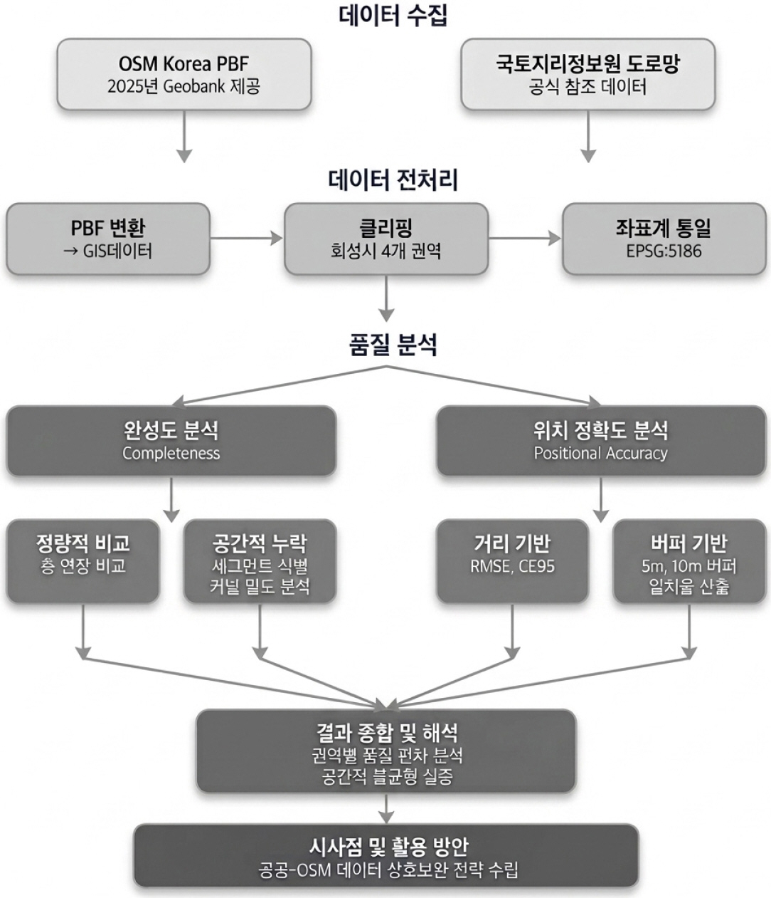
- This study evaluates the completeness and positional accuracy of the OpenStreetMap (OSM) road network in four districts of Hwaseong Special City by comparing it with the official road network provided by the National Geographic Information Institute (NGII). The 2025 OSM Korea PBF data and the official road network data were transformed into the same coordinate system, and district-level analyses were conducted using total road length-based completeness, spatial distribution of missing roads, RMSE, and 5 m and 10 m buffer-based positional matching rates. The results show substantial regional variation in completeness: Dongtan District recorded 137.93%, Byeongjeom District 99.37%, Hyohaeng District 68.75%, and Manse District 56.33%. Positional accuracy was generally favorable, with RMSE values ranging from 2.02 to 4.41 m. However, the completeness value exceeding 100% in Dongtan District should be interpreted as a relative result caused by differences in road-type coverage, including footways, cycleways, and service roads in OSM. This study highlights the potential for complementary use of public road network data and OSM.
- COLLAPSE
본 연구는 화성특례시 4개 권역을 대상으로 OpenStreetMap(OSM) 도로망의 완성도와 위치 정확도를 국토지리정보원 공식 도로망과 비교하여 평가하였다. 2025년 OSM Korea PBF 자료와 공식 도로망 자료를 동일 좌표계로 변환한 뒤, 총연장 기반 완성도, 누락 도로의 공간분포, RMSE 및 5m·10m 버퍼 기반 위치 일치율을 분석하였다. 분석 결과, 완성도는 동탄구 137.93%, 병점구 99.37%, 효행구 68.75%, 만세구 56.33%로 권역별 차이가 컸으며, 위치 정확도는 RMSE 2.02~4.41m로 전반적으로 양호하였다. 다만 동탄구의 100% 초과 완성도는 분석에서 이용한 OSM과 공식 도로망 간 도로 유형 포함 범위의 차이에 따른 상대적 결과로 해석할 필요가 있다. 본 연구의 결과는 공식 도로망과 사용자 참여를 통해 작성한 OSM 도로망 간의 상호 보완적 활용의 가능성을 제시한다.
-
Assessment of OpenStreetMap Road Network Completeness and Positional Accuracy: A Case Study of Hwaseong Special City
-
Research Article
-
Process of Change in the Central Region and Geographic Range of Jeonju City
전주시의 중심 지역과 지리적 범위 변화 과정
-
Sungwook Cho
조성욱
- In this study, the development process of the Jeonju City was divided into three periods and examined the change of the central …
이 연구에서는 전주시의 발전 과정을 3개 시기로 구분하여, 중심 지역과 지리적 범위의 변화 과정을 살펴봤다. 연구를 통해 밝혀진 내용을 정리하면, 첫째, 전주의 …
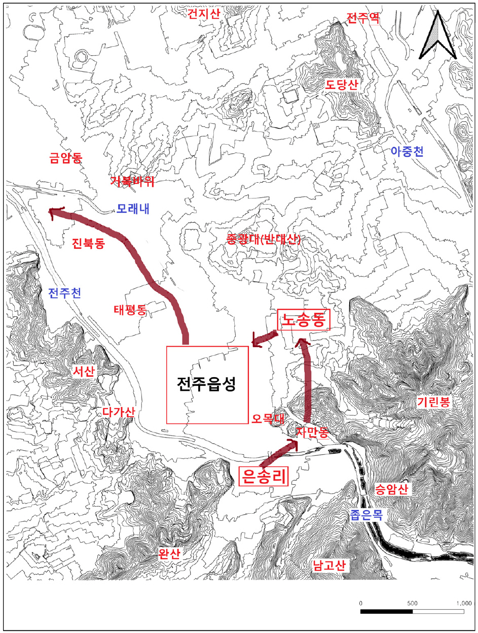
- In this study, the development process of the Jeonju City was divided into three periods and examined the change of the central region and expanding the geographic range. To summarize this study, First, the change of the central region in the Jeonju area expanded from Eunsong-ri to Nosong-dong in the Mahan and Baekje periods, along with population growth. During the Unified Silla Period, flatland area grew into a new center and Gyeonwhon Castle was built in the Nosong-dong area as it became the capital of Later-Baekje. After the fall of Later-Baekje, the regional center moved back to the flatland, the Jeonju Walled Town was built in 1388, and the central region was maintained to the Joseon Dynasty. Jeonju Walled Town was disbanded in 1907, but its role as a regional center continued until 1980, and later it became a multi-core city. Second, the geographic range of Jeonju to the Joseon Dynasty was Nosong-dong hilly area to the east, Jeonju Stream basin to the west, Moraenae Stream to the north, and Girin Mountain and Seungam Mountain to the south. However, it expanded north and west in the 1940s, its geographical range expanded sharply in 1957, and in the 1980s has expanded from northwest along Jeonju Stream to hilly areas in the east-west directions. After the 2000s, it went beyond Samcheon and Hwangbang Mountain, which were recognized as the outer borders of Jeonju. The present boundaries are Soyang Stream in the east, Chonjam Mountain in the west, Moak Mountain in the south, and Mangyeong River in the north.
- COLLAPSE
이 연구에서는 전주시의 발전 과정을 3개 시기로 구분하여, 중심 지역과 지리적 범위의 변화 과정을 살펴봤다. 연구를 통해 밝혀진 내용을 정리하면, 첫째, 전주의 중심 지역은 마한 및 백제시대에 은송리 지역에서 시작하여, 인구 증가와 함께 노송동 구릉 지역으로 이전되었다. 통일신라시대에는 전주읍성 지역이 새로운 중심지로 성장하였고, 후백제의 도읍이 되면서 노송동 지역에 견훤도성이 축조되었다. 후백제 멸망 이후 다시 평탄지인 전주읍성 지역으로 중심 지역이 이전되었고 이곳에 1388년 전주부성이 축조되었으며, 조선시대까지 중심 지역이 유지되었다. 1907년 전주 읍성이 해체되었지만, 중심 지역으로서의 역할은 1980년까지 이어졌고, 이후에는 다핵심도시로 변화했다. 둘째, 전주의 지리적 범위는 조선시대까지 동쪽으로는 노송동 구릉 지역, 서쪽으로는 전주천 유역, 북쪽으로는 모래내, 남쪽으로는 기린봉과 승암산의 지리적 범위였다. 그러나 1940년대에 북쪽과 서쪽으로 확대되었고, 1957년에 지리적 범위가 급격하게 확장되었으며, 1980년대에는 전주천을 따라 북서쪽으로 확대되던 발전 방향이 동서 방향의 구릉지 개발로 횡적 확대가 이루어졌다. 2000년대 이후에는 그동안 전주의 외곽 경계로 인식되었던 삼천과 황방산을 넘어, 동쪽은 소양천, 서쪽은 천잠산, 남쪽은 모악산, 북쪽은 만경강으로 확장되었다.
-
Process of Change in the Central Region and Geographic Range of Jeonju City
-
Research Article
-
Multi-scalar Spatial Organization of Religious Cosmology: The Morphological Realization of Tri Hita Karana in Bali
종교적 우주관의 다층위 공간 조직: 발리 ‘트리 히타 카라나’의 형태론적 구현
-
Khan Yong Lee
이간용
- Human settlements can be understood not merely as physical environments but as spatial manifestations of a society’s religious cosmology and value system. …
인간의 거주 공간은 단순한 물리적 환경이 아니라 특정 문화 집단의 종교적 우주관과 가치 체계가 공간적으로 구현된 결과물로 이해될 수 있다. 이에 본고는 …
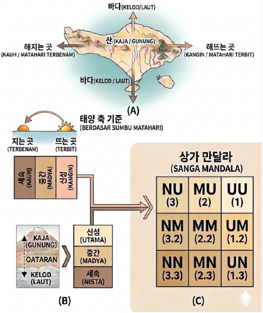
- Human settlements can be understood not merely as physical environments but as spatial manifestations of a society’s religious cosmology and value system. This study examines how the Balinese Hindu philosophy of Tri Hita Karana is embodied in spatial organization across multiple scales. Moving beyond previous studies that focused on individual spatial units such as houses, villages, or Subak systems, it explores the integrated structure of multi-scalar spatial organization from domestic to ecological-production spaces. The findings show that a common cosmological order is repeatedly expressed across different spatial scales. The house(Pekarangan) functions as a microcosm reproducing sacred and secular order; the village(Desa) organizes communal space through the Kaja–Kelod axis and the three-temple system; and the Subak operates as a macro-scale system linking religious cosmology with ecological management through water temples and terraced rice fields. Tri Hita Karana thus functions as a multi-scalar organizing principle integrating spatial arrangement, directional order, social hierarchy, and ecological relationships.
- COLLAPSE
인간의 거주 공간은 단순한 물리적 환경이 아니라 특정 문화 집단의 종교적 우주관과 가치 체계가 공간적으로 구현된 결과물로 이해될 수 있다. 이에 본고는 인도네시아 발리의 힌두 철학인 트리 히타 카라나(Tri Hita Karana)를 중심으로, 종교적 우주관이 다양한 공간 규모 속에서 어떠한 공간 조직 원리로 구현되는지를 고찰하였다. 특히 기존 연구들이 가옥, 취락, 수박(Subak) 등 개별 공간 단위에 집중해 온 한계를 비판적으로 검토하면서, 미시적 생활 공간에서 거시적 생태·생산 공간에 이르는 다층위 공간 조직(multi-scalar spatial organization)의 구조와 상호 연계성을 통합적으로 분석하고자 하였다. 분석 결과, 발리의 공간 체계는 공통된 우주론적 질서가 서로 다른 공간 규모 속에서 반복·변주되며 구현되는 유기적인 특성을 보였다. 가옥(Pekarangan)은 신성과 세속의 질서를 재현하는 미시적 소우주로 기능하였으며, 취락(Desa)은 카자-클로드(Kaja-Kelod) 축과 3대 사원 체계를 중심으로 공동체 규모의 종교적 공간 질서를 조직하고 있었다. 또한 수박은 물 사원 네트워크와 계단식 논 경관을 통해 종교적 우주관과 생태적 질서가 결합된 거시적 공간 체계로 작동하였다. 결과적으로 트리 히타 카라나는 공간 배치와 방향 체계, 사회적 위계 및 생태적 관계를 통합적으로 조직하는 다층위 공간 조직 원리로 기능하고 있음을 확인할 수 있었다.
-
Multi-scalar Spatial Organization of Religious Cosmology: The Morphological Realization of Tri Hita Karana in Bali
-
Research Article
-
Selection of Diagnostic Indicators for Rural Sprawl and Analysis of Mixed-use Types in the Era of Local Extinction: Focused on the Case of Hwasun-gun, Jeollanam-do
지방소멸시대의 농촌공간 난개발 진단지표 선정 및 혼재유형 분석: 전라남도 화순군 사례를 중심으로
-
Mun-Hyun Jang
장문현
- This study develops diagnostic indicators for rural sprawl under the premise of revitalizing rural space facing local extinction and classifies mixed-use types …
본 연구는 소멸위기에 직면한 농촌공간의 활성화를 전제로 난개발 진단지표를 개발하고, 핵심적인 난개발 관련 시설의 혼재유형을 분류하였다. 이를 연구의 대상지인 화순군에 적용하여 혼재유형별 …
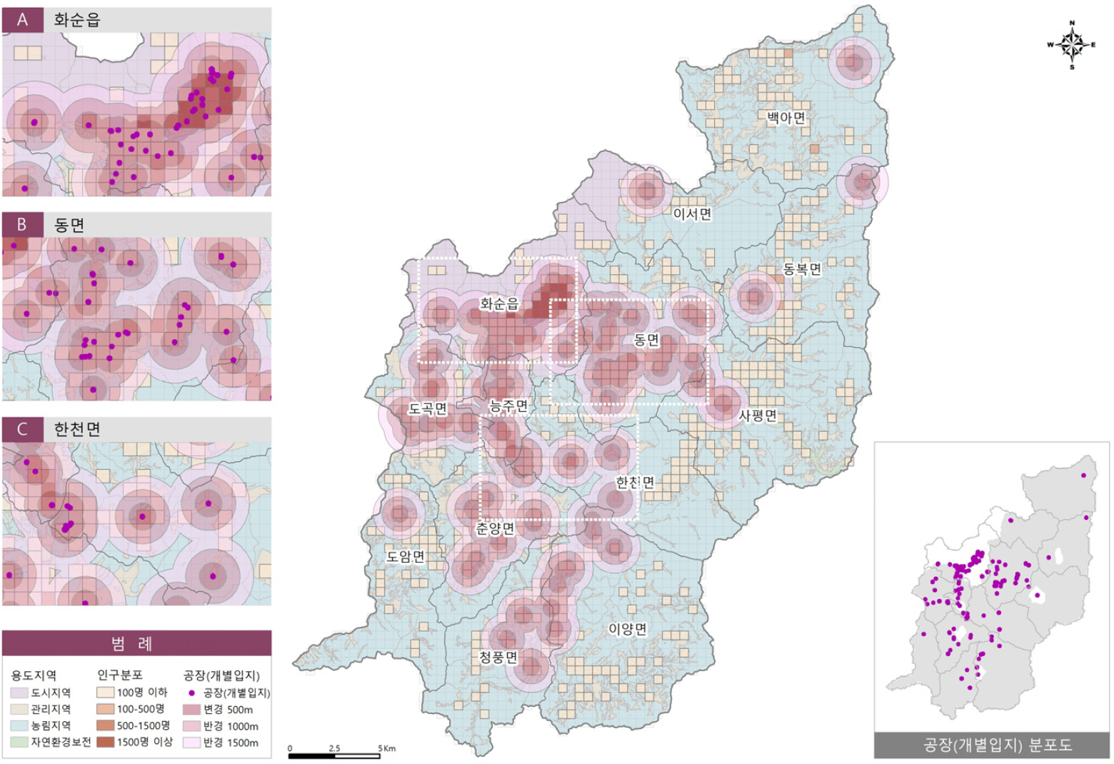
- This study develops diagnostic indicators for rural sprawl under the premise of revitalizing rural space facing local extinction and classifies mixed-use types of key facilities associated with rural sprawl. The framework was applied to the case study area of Hwasun-gun to analyze the distribution of mixed-use types and the spatial characteristics by land-use zoning. The results are as follows. First, 93.9% of rural sprawl facilities, including factories, livestock facilities, and solar power facilities, were located in rural areas. Second, 83.8% of the rural population was found to reside within a 500m radius of such facilities. Third, among the mixed-use types, Type-Ⅰ(residential-factory) was mainly distributed in planned management areas, while Type-Ⅱ(residential-livestock) and Type-Ⅲ(residential-solar power) were predominantly located in agricultural and forestry areas. Fourth, overall, rural sprawl facilities tended to concentrate in planned management areas adjacent to urban regions and in agricultural and foresty areas with relatively high accessibility. The findings contribute to establishing a diagnostic system for sprawl in rural space, where both crisis and opportunity coexist, and are expected to support rational decision-making in the process of restructuring rural space within institutional frameworks. However, the calculation and standardization of indices using diagnostic indicators, as well as the analysis of the degree of mixed use, are left for future research.
- COLLAPSE
본 연구는 소멸위기에 직면한 농촌공간의 활성화를 전제로 난개발 진단지표를 개발하고, 핵심적인 난개발 관련 시설의 혼재유형을 분류하였다. 이를 연구의 대상지인 화순군에 적용하여 혼재유형별 분포 및 용도지역별 공간특성을 분석하였다. 그 결과 첫째, 공장·축사·태양광시설 등 난개발 시설의 93.9%가 농촌지역에 입지하였다. 둘째, 난개발 시설로부터 500m 이내에 농촌인구의 83.8%가 거주하는 것으로 분석되었다. 셋째, 혼재유형 중 Type-Ⅰ(주거·공장)은 계획관리지역, Type-Ⅱ(주거·축사) 및 Type-Ⅲ(주거·태양광)은 농림지역에 다수가 분포하였다. 넷째, 전체적으로 도시권에 인접한 계획관리지역과 상대적으로 접근이 용이한 농림지역에 난개발 시설이 집중되는 양상을 보였다. 결과적으로 연구성과는 시대적 위기와 기대가 공존하는 농촌의 난개발 진단체계 정립에 기여하고, 나아가 제도적 틀 속에서 농촌공간 재구조화 과정에 합리적인 의사결정을 지원할 것으로 기대된다. 다만, 진단지표를 활용한 지수 산출 및 표준화, 혼재도 분석 등은 향후 후속적인 연구를 통해 수행할 계획이다.
-
Selection of Diagnostic Indicators for Rural Sprawl and Analysis of Mixed-use Types in the Era of Local Extinction: Focused on the Case of Hwasun-gun, Jeollanam-do

Journal Informaiton
 Journal of the Association of Korean Geographers
Journal of the Association of Korean Geographers


한국지리학회
105, Academic Affairs Office, 1st floor, College of Education, Dongguk University, Hakrim Hall (J Building), 30, Pildong-ro 1-gil, Jung-gu, Seoul 04620, Korea
Tel: +82-2-2260-3108 / Fax: +82-2-2260-3113 / E-mail: geography.akg@gmail.com Copyright© The Association of Korean Geographers. Powered by APUB
Tel: +82-2-2260-3108 / Fax: +82-2-2260-3113 / E-mail: geography.akg@gmail.com Copyright© The Association of Korean Geographers. Powered by APUB